1976 Tangshan earthquake
One of the deadliest earthquakes in recorded history.

From a variety of images credited above. · CC BY 4.0
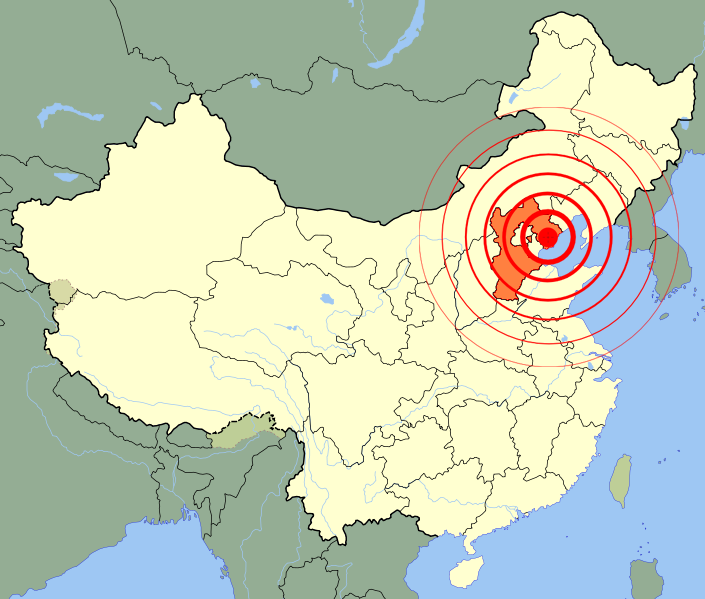
The 1976 Tangshan earthquake struck the region around Tangshan, Hebei, China, at 03:42:55 on 28 July (19:42:55, 27 July UTC). It is considered one of the deadliest earthquakes in recorded history, though not the deadliest, and one of the worst disasters in China by death toll.
- Date
- 28 July 1976
- Magnitude
- Mw 7.6
- Maximum Intensity
- XI (Extreme) on the Mercalli scale
- Location
- Tangshan, Hebei, China
- Economic Loss
- 10 billion yuan
Lore & Background
The earthquake sequence comprised two shocks of magnitude at least 7.0. The first, at 3:42:55 local time, was approximately 12 km under southern Tangshan, rupturing along a vertically dipping, northeast-trending right-lateral strike-slip fault. A second main shock of Mw 7.1 struck that afternoon near Luanxian, about 70 km to the east-northeast, in a zone of conjugate faults. A long sequence of aftershocks followed, with twelve of magnitude 6 or greater, including a M 6.2 shock near Ninghe three and a half hours after the initial quake and a M 6.9 aftershock in November near Ninghe.
Reader's Guide
The Tangshan earthquake remains a landmark event in seismology and disaster history. The disaster highlighted the severe consequences of underestimating seismic risk: almost all buildings in Tangshan were unreinforced brick structures built without seismic considerations, and the city sat directly atop a major fault line. The earthquake's shallow depth converted much of its energy to surface shaking, causing extreme damage across a meizoseismal area 10.5 km long and up to 5.5 km wide. The economic loss totaled 10 billion yuan.
Did You Know?
- The earthquake struck at 03:42:55 local time on 28 July 1976, when most residents were asleep.
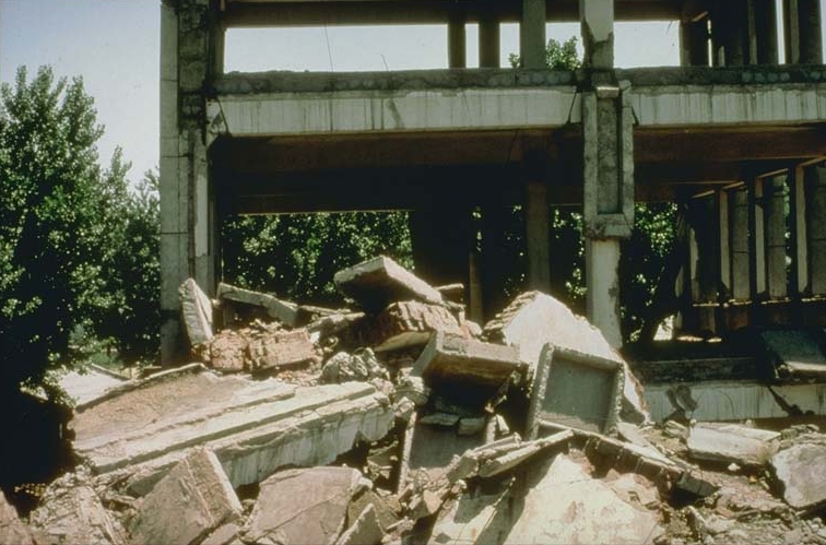
- 85 percent of buildings in Tangshan collapsed or were rendered unusable within minutes.
- The maximum intensity was XI (Extreme) on the Mercalli scale, and the shaking was felt up to 1,100 km away across northeastern China, Mongolia, and Korea.
- The Tangshan fault that ruptured runs right under the center of Tangshan City.
Catastrophic Impact and Human Loss
The early-morning hours of 28 July 1976 brought near-instantaneous annihilation to the industrial city of Tangshan. At 3:42:55 a.m., a magnitude 7.6 earthquake struck with a maximum shaking intensity rated XI—Extreme—on the Mercalli scale. Within mere minutes, roughly 85 percent of the city's buildings either collapsed outright or became structurally unsalvageable. Every public-service infrastructure failed simultaneously, and the majority of highway and railway bridges were either destroyed or left in such severe disrepair that they could no longer carry traffic. The human cost remains staggering by any historical measure. Official Chinese records tallied 242,469 fatalities, yet many historians argue the true figure exceeded 300,000 lives lost. By that accounting, the Tangshan disaster stands as the single deadliest earthquake ever documented in the modern era, surpassed only by the 1556 Shaanxi event when one factors in the subsequent famine deaths. It also ranks among the most lethal natural disasters in the entire history of China, a testament to how concentrated the destruction was within a single urban center struck while its residents slept.
Geological Vulnerability of the Region
Tangshan sits at the northern margin of the Beijing-Tianjin-Tangshan Plain, a vast alluvial expanse stretching from the capital to the Bohai Sea. This plain, the northeastern lobe of the broader North China Plain, was built up by sediments eroded from the Yanshan Mountains and deposited into what was once the ancient Bohai Sea. Tangshan lies close to where the shoreline stood roughly four thousand years ago. Beneath the city the sedimentary fill is thinner than to the south, where weak soils reach nearly three kilometres deep. Instead, a ten-kilometre-thick sequence of limestone, sandstone, and coal-bearing strata crops out as isolated hills. Tangshan rests above a northeast-trending syncline that has pushed vast coal seams close enough to the surface for mining. Deeper still lies the metamorphic basement of the North China Craton's Eastern Block, assembled roughly two billion years ago by the collision of two continental plates. The Yanshan fault-fold belt to the north marks the craton's edge, and it is where several fault zones terminate against the mountains. Over half of Hebei province's destructive earthquakes have occurred in this zone. Reactivation of these ancient faults by the ongoing Indian-Eurasian plate collision has made the region extraordinarily dangerous seismically, accounting for six of the ten deadliest earthquakes in the historical record.
Mechanics of the Two Main Shocks
The 28 July event was not a single rupture but a pair of major shocks. The first, initially estimated at magnitude 8.1 before being recalculated to 7.6 Mw, struck at 3:42:55 a.m. roughly twelve kilometres beneath Tangshan's southern district. Because the hypocentre was shallow, a large fraction of the released energy was converted directly into surface shaking, registering 7.6 on the standard surface-magnitude scale and 7.8 on China's own scale. The rupture propagated along a vertically dipping, northeast-trending right-lateral strike-slip fault, extending roughly 140 kilometres from the epicentre. The crust on the southeast side of the fault shifted about three metres to the southwest, driven by tectonic compression along a nearly west-east axis. At the surface, five en echelon rupture segments traced an eight-kilometre path through the heart of the city. The second main shock, magnitude 7.0 Mw (7.4 Ms), followed that same afternoon at 18:45 near Luanxian, some 70 kilometres to the east-northeast. It ruptured along a set of north-northwest-striking conjugate faults with left-lateral motion. The opposing sense of slip on the two faults indicates that the crustal block sandwiched between them was being squeezed southward as the western and eastern blocks compressed together.
Aftershock Sequence and Ongoing Seismic Legacy
The main shocks were followed by a prolonged aftershock sequence that included twelve events of magnitude 6 or greater. The first of these struck just three and a half hours after the initial quake, at 7:17 a.m., near Ninghe at the southern end of the Tangshan fault, registering 6.2 on the surface-magnitude scale. A second significant aftershock, magnitude 6.9, shook the same Ninghe area in November. The bulk of aftershock activity concentrated in a zone roughly 140 kilometres long and 50 kilometres wide, spanning the length of the fault, and many buildings already weakened by the main shock suffered further collapse. The seismic legacy of 28 July has not faded. The aftershock zone remains active into the twenty-first century. Moderate tremors of 4.5 to 4.7 Ms were recorded in 2012, 2016, and 2019. On 12 July 2020, a 5.1 Ms strike-slip earthquake struck the northern segment of the Tangshan fault, generating its own short aftershock sequence that subsided by 17 July. While that event caused only minor structural damage in Tangshan, its occurrence reignited debate among seismologists about the long-term hazard posed by the still-active fault system beneath the city.
Gallery



Frequently Asked Questions
Who is 1976 Tangshan earthquake?
It refers to the devastating seismic event that struck the Tangshan area in Hebei Province, China, in the early hours of July 28, 1976. The shaking was recorded at 3:42 AM local time and registered a moment magnitude of 7.6.
What are 1976 Tangshan earthquake's powers/role?
The quake's energy release flattened roughly 85 percent of the city's structures and produced maximum shaking rated as Extreme (XI) on the Mercalli intensity scale. It functioned as a sudden, total-annihilation force on an industrial city that had no prior seismic preparedness.
Why is 1976 Tangshan earthquake important?
It ranks among the most lethal earthquakes ever documented in the modern era and remains one of the single worst natural-disaster death tolls in Chinese history. The event also became a long-suppressed topic in official Chinese discourse, which shaped how the country later approached disaster transparency and emergency response.
Where does 1976 Tangshan earthquake take place?
The epicenter was situated in the Tangshan metropolitan area within Hebei Province, just north of Beijing. The destruction was concentrated in the urban core and surrounding industrial districts of that region.
More in Natural Disasters 1-15
Spotted an error? Know more?
This is a living reference — every entry is fact-audited, and reader corrections feed straight into our audit queue. Suggest an edit · See this site's audit record