2023 Turkey–Syria earthquakes
Deadliest earthquake in modern Turkey and Syria since antiquity.

Gazozlu · CC BY-SA 4.0
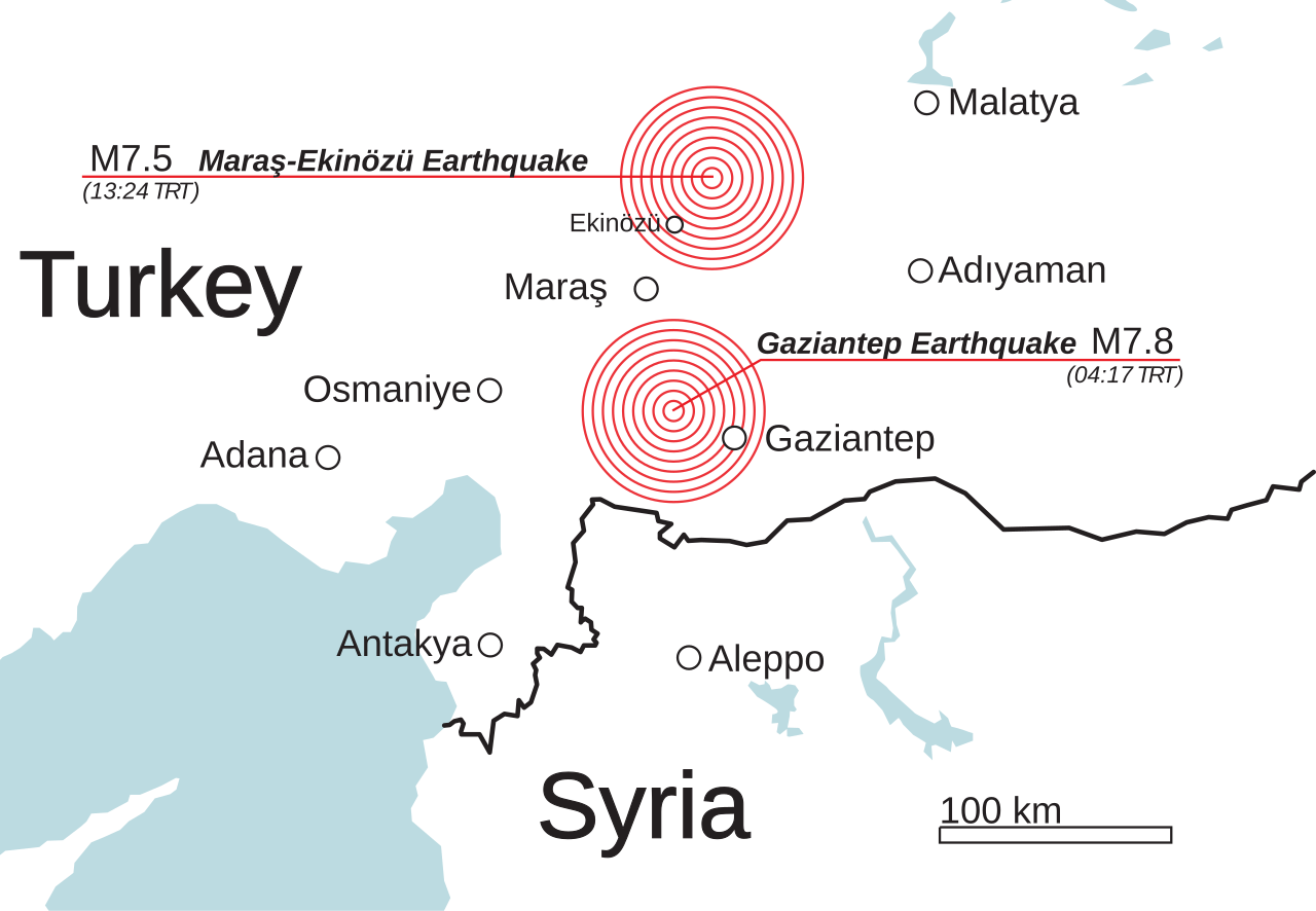
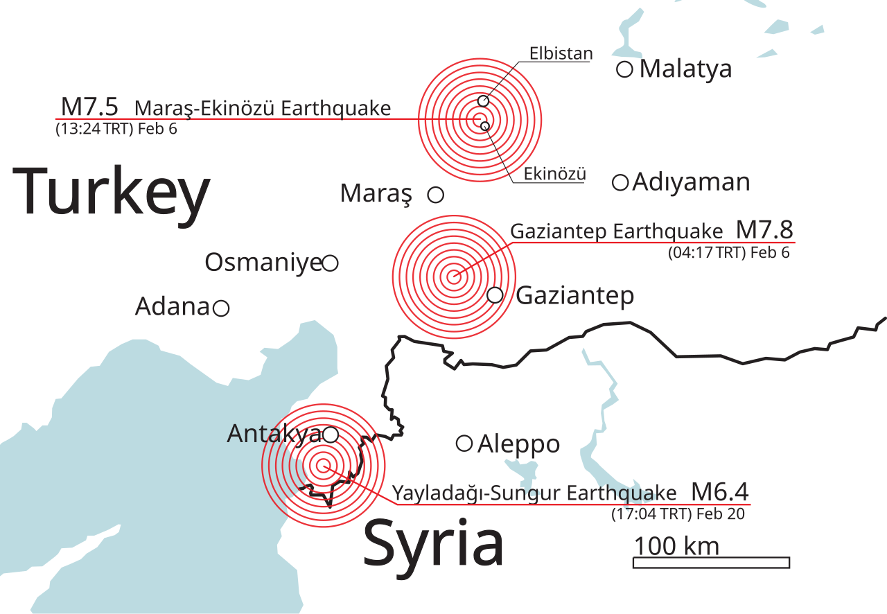
The first earthquake, a moment magnitude (Mw) 7.8 event, occurred at 04:17:35 TRT (01:17:35 UTC), followed by a Mw 7.7 earthquake at 13:24:49 TRT (10:24:49 UTC). These earthquakes caused widespread severe damage, tens of thousands of fatalities, and are among the strongest ever recorded in Turkey and the Levant.
- Magnitude
- Mw 7.8 and Mw 7.7
- Epicenter (first)
- 37 km west–northwest of Gaziantep
- Epicenter (second)
- 95 km north-northeast from the first
- Estimated damage
- US$150 billion in Turkey, US$9 billion in Syria
Lore & Background
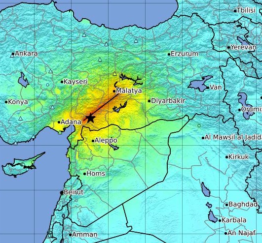
The seismic sequence resulted from shallow strike-slip faulting along segments of the Dead Sea Transform, East Anatolian and Sürgü–Çardak faults. It was felt as far as Egypt and the Black Sea coast of Turkey. Damaged roads, winter storms, and disruption to communications hampered rescue efforts. An estimated 14 million people, or 16 percent of Turkey's population, were affected, and about 1.5 million people were left homeless.
Reader's Guide
The Mw 7.8 and Mw 7.7 earthquakes, occurring within hours of each other, are the largest and only observed to occur on land within such a short span of time. The event highlighted the seismic hazard along the Dead Sea Transform and East Anatolian Fault systems, where large historical earthquakes have caused tens of thousands to hundreds of thousands of fatalities. The damage, estimated at US$150 billion in Turkey (nine percent of its GDP) and US$9 billion in Syria (18 percent of its GDP), demonstrates the profound economic impact.
Did You Know?
- An estimated 1.5 million people were left homeless across the affected region.
- The damage was estimated at US$150 billion in Turkey, or nine percent of its gross domestic product.
The Twin Quakes of February 6
On the early morning of February 6, 2023, a devastating Mw 7.8 earthquake struck at 04:17:35 local time, its epicenter located roughly 37 kilometers to the west-northwest of Gaziantep. The shallow strike-slip rupture produced Mercalli intensity XII—extreme shaking—both near the epicenter and in the city of Antakya. Just over nine hours later, at 13:24:49, a second major shock of Mw 7.7 followed, centered approximately 95 kilometers to the north-northeast of the first event. Together, these two quakes represented the most powerful seismic activity to hit Turkey since the 1939 Erzincan earthquake of equal magnitude, and they rank as the second-largest in the country's recorded history, trailing only the larger estimates for the 1668 North Anatolia event. The shaking was so intense it registered as far away as Egypt and Turkey's Black Sea coast. In the three months that followed, more than 30,000 aftershocks continued to rattle the region. The entire sequence was driven by shallow strike-slip faulting along segments of the Dead Sea Transform, the East Anatolian Fault, and the Sürgü–Çardak Fault system.
A Crossroads of Tectonic Plates
The region where these quakes struck sits at a critical junction where three major tectonic plates interact: the African plate, the Arabian plate, and the Anatolian sub-plate. The Dead Sea Transform, a major left-lateral strike-slip boundary, marks the divide between Africa and Arabia, accommodating Arabia's steady northward drift. At its northern terminus, the transform meets the East Anatolian Fault, another left-lateral system that channels the westward extrusion of the Anatolian plate as Arabia pushes northward. These two structures converge at the Marash triple junction. The East Anatolian Fault stretches roughly 700 kilometers and is divided into seven named segments, with slip rates declining from about 10 millimeters per year in the northeast to roughly 2.9 millimeters per year in the southwest. A parallel northern strand, including the Sürgü and Çardak segments, runs east-west for about 160 kilometers north of the main fault. The northern portion of the Dead Sea Transform is itself subdivided into multiple segments, though geologists still debate exactly which structures belong to the transform versus the East Anatolian system at the very northern end.
A Catastrophe Without Modern Parallel
The human cost of the February 2023 quakes is staggering by any measure. In Turkey alone, 53,537 people were confirmed dead, while in Syria the toll ranged between 5,951 and 8,476 fatalities. This makes the event the deadliest earthquake in present-day Turkey since the 526 Antioch earthquake and the most lethal natural disaster in the country's modern history. For Syria, it surpasses the 1822 Aleppo earthquake as the worst quake in the nation's contemporary era. Globally, it stands as the deadliest earthquake or natural disaster since the 2010 Haiti tragedy and ranks as the fifth-deadliest earthquake of the entire twenty-first century. The physical destruction was equally vast: an area of roughly 350,000 square kilometers—comparable in size to Germany—suffered widespread damage. An estimated 14 million people, representing about 16 percent of Turkey's total population, were affected, and United Nations development experts assessed that approximately 1.5 million individuals were left without homes. Economic losses were estimated at 150 billion US dollars in Turkey, equivalent to nine percent of its GDP, and 9 billion dollars in Syria, or 18 percent of that nation's GDP.
A Rescue Effort Stretched to Its Limits
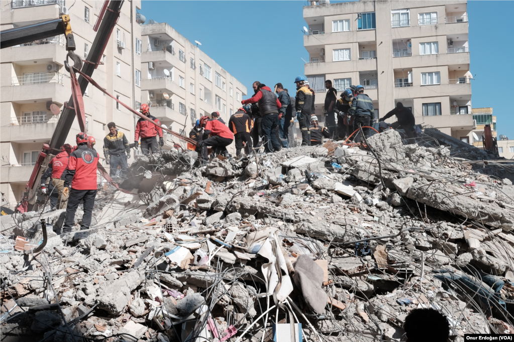
The immediate aftermath posed enormous logistical challenges for Turkey's Disaster and Emergency Management Presidency. Collapsed road networks, severe winter storms, and broken communications systems all compounded the difficulty of reaching trapped survivors. Despite these obstacles, the national response mobilized 60,000 search-and-rescue workers, 5,000 health professionals, and 30,000 volunteers to comb through rubble across the affected region. Recognizing the scale of the catastrophe far exceeded domestic capacity, Turkey issued a formal call for international assistance. The response was extraordinary: more than 141,000 personnel from 94 different countries joined the rescue and relief operations, supplementing the domestic workforce with a vast multinational presence. Yet the combination of the quakes' sheer destructiveness, the winter conditions, and the vast geographic spread of damage—covering an area the size of Germany—meant that rescue teams faced severe constraints in reaching all affected areas. The tens of thousands of fatalities that ultimately emerged from the rubble underscore how the speed and reach of rescue operations, however heroic, could not fully overcome the scale of the destruction.
Gallery
Frequently Asked Questions
Where were the epicenters of the two main quakes?
The first epicenter lay roughly 37 km west-northwest of Gaziantep, and the second was about 95 km north-northeast of that point. Both struck along the Turkey–Syria border zone, affecting southern and central Turkey as well as northern and western Syria.
Why do seismologists consider this event historically significant?
A pair of M7+ quakes in a single day ranks among the strongest ever measured in Turkey and the broader Levant. It is widely cited as the most lethal seismic disaster in the region since ancient times.
What made the destruction so severe beyond the initial ground motion?
The second Mw 7.7 quake struck only hours after the first, hitting areas already structurally compromised and catching rescue services before they could fully mobilize. The compounded damage across both countries led to tens of thousands of building collapses and massive displacement.
More in Natural Disasters 1-15
Spotted an error? Know more?
This is a living reference — every entry is fact-audited, and reader corrections feed straight into our audit queue. Suggest an edit · See this site's audit record